Area guide: Hiking the Smokies
Our recommendations for planning your hike in the Great Smoky Mountains National Park
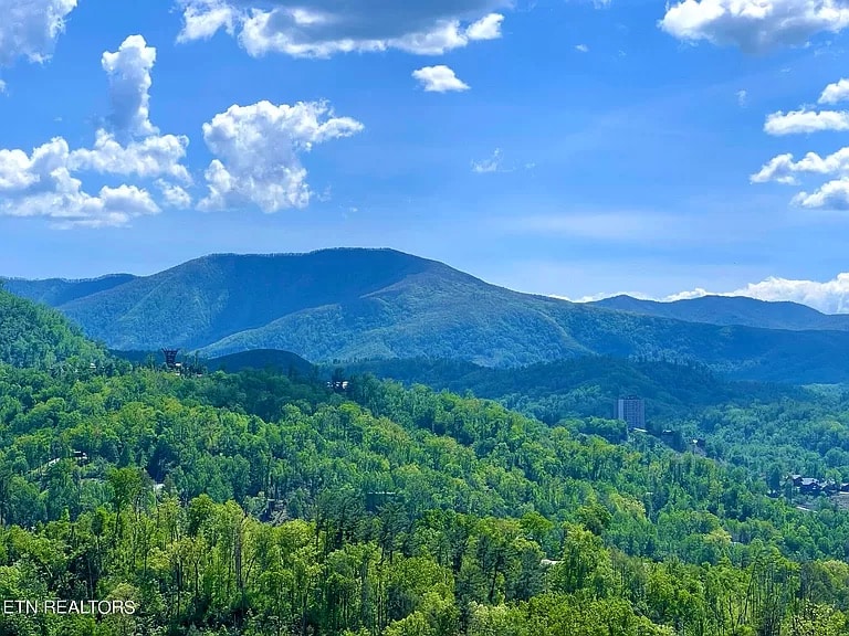
In Gatlinburg, you are right on the edge of the Great Smoky Mountains National Park. The beauty of these ancient mountains is best enjoyed by walking in them – whether for just a shorter outing or a full-day or multi-day hike.
There are several entrances to the park – the Sugarlands entrance in Gatlinburg is the most popular, but note that you are just next to the lesser-known Greenbrier entrance, which has some of our favorite trails and is also useful if there are crowds at the Gatlinburg entrance.
We have listed a few of our favorite trails in this guide, but there are many many more trails and we would also recommend that you have a look at a trail listing when planning your hike. Our recommended online listings are:
The latter is particularly good for getting a list of trails by location. Make sure that you pick a trail that is within the comfort zone of the least experienced hiker in your group.
See all of our recommendations in our guide for Gatlinburg and the Smoky Mountains!
Park entrances near Gatlinburg
Sugarlands Entrance and Visitor Center
The Sugarlands entrance is the main way into the park, which you’ll reach going through Gatlinburg. Visit the Sugarlands Visitors Center for more information about hiking the park.
Greenbrier Entrance
The Greenbrier entrance to the park is much calmer but has some great trails to hike. It is not well marked and can be easy to miss – keep an eye out on your left on the East Parkway after you pass the Pittman Center Rd (416) and then the Little Pigeon River.
Townsend Entrance
The Townsend entrance is a bit further away from Gatlinburg, but tends to be a bit quieter. The best entrance if you are heading to the Great Smoky Mountains Institute at Tremont or Cades Cove.
Guided park tours

A good way to experience the National Park is with a knowledgeable local guide who can help you see parts of the Smokies you might otherwise miss. We think that the best guides can be found with A Walk in the Woods. They have a wide variety of walks – we would recommend one of the following:
- Thundering Streams and Falls of the Smokies (3 hrs) (starting at 1138 Parkway)
- Hidden Cascade Hiking Tour (4 hrs) (starting at 1138 Parkway)
- Explore a Simpler Time (3 hrs) (starting at the Greenbrier entrance)
- Old Growth Forest Cascade (8 hrs) (starting at the Greenbrier entrance)
- Or if you have time for a longer hike: Overnight Backpacking in the Smokies (starting at the Greenbrier entrance)
You can explore their full list of hikes at https://awalkinthewoods.com/
Recommended trails
Greenbrier – Ramsey Cascades Trail
We consider this to be the best waterfalls hike in the park – and it is very close to the cabin and tends to not be very busy. The trail is about 8 miles and you should be in reasonably good shape to attempt it. Enter via the Greenbrier entrance, take a left onto the Ramsey Prong Road, and continue to the Ramsey Cascades trailhead parking.
Greenbrier – Porters Creek Trail
Porters Creek Trail is the other main trail you can access via the Greenbrier entrance to the park. This is a great choice for an easier hike – about 4 miles long. Beautiful flowers particularly in the spring.
Mt LeConte – Alum Cave Bluffs Trail
A quite challenging out-and-back trail going up to Mt LeConte – but the views are just astounding. At close to 11 miles and close to 3000 ft in elevation gain, only attempt it if you are in reasonably good shape. In the winter, make sure to wear ice spikes and bring hiking sticks. In the summer, the parking lot can fill up quickly, so get there early.
There are also other trails up to Mt LeConte – including the Boulevard Trail, Bullhead Trail, Rainbow Falls Trail, and Trillium Gap Trail.
Middle Prong Trail
While a bit longer drive from Gatlinburg to get to the trailhead – enter via Townsend – this is considered by many the best waterfalls trail in the park, with three beautiful waterfalls.
Clingmans Dome Trail
For an easy walk that still rewards you with amazing views from the highest peak of the park, head for the Clingmans Dome Trail, leading up to the observatory on the top.
Picnic areas
Chimneys Picnic Area
Nice picnic spot next to a creek with parking, picnic tables, and restrooms. If you want a good spot, try to come early. If you want to climb down to the creek or swim in it, make sure to bring water shoes (or sneakers that you don’t mind getting wet) with soles with a good grip
View this location in our guide
Greenbrier Picnic Area
The picnic area in the Greenbrier Entrance has tables and grills in a picturesque setting.
Motor trails
For those of you who are not up for a hike, it is also possible to enjoy the park and its surroundings on one of the motor trails and scenic roads.
Roaring Fork Motor Nature Trail
This 6-mile one-way loop gives you plenty of opportunities to enjoy both the mountain scenery and some of the historic buildings in the park. This is also the way to access the trailheads for the Rainbow Falls Trail and the Trillium Gap Trail. There is also a waterfall accessible without hiking – the Place of a Thousand Drips is near stop 15, near the end of the Roaring Fork Motor Nature Trail.
View this location in our guide
Cade’s Cove Scenic Loop
If you have an interest in history, the Cade’s Cove Scenic Loop is highly recommended – it features a variety of restored pioneer buildings: churches, log homes, barns, and a mill. There are plenty of opportunities to stop and look around on the drive, and you’ll also find a visitors center on the loop road.
As it can be a very popular sight, we recommend that you start early (and if possible, go on a weekday) to beat the crowds.
View this location in our guide
Foothills Parkway
The plan for the Foothills Parkway was approved in 1944, but only part of it has been completed, with the latest section opened in 2018. Head over to Wears Valley for a drive with some of the most amazing views you can find in the country.